


Click on the route sign for more details …
From Busteni station (883 m) we turn left into Libertatii Avenue (interstate) till Industriei street (10 min from the station). From this point we turn right into this street being able to admire the the Bucegi Mountains dominated by Vf. Claia Mare and the steep side of Caraiman. In 20-25 min from Libertatii Avenue, we reach the right bank of V. Jepi, where the path to Urlatoarea (marked red dot) goes left. Our trail goes into the road but at the fisrt curve it leaves it behind, following left the path marked blue triangle, then it goes over a pipe, and by a small hamlet, after that it climbs through the forest and in 10-15 min from the junction it reaches “La Gratar” spot. In here it crosses the water canal which comes from V.Urlatorilor (along this canal, on the bridge, there is the trail to Urlatoarea Water fall), goes under the ski lift and then, in 200 m from “La Gratar” hamlet, it crosses Valea Seaca a Jepilor (or Valea Seaca which leads into Braul Mare al Jepilor, a large plateau which is a starting point for trails to Peretele cu Florile and Vf. Claii Marii, goes up through the forest into “La Vinclu” (in 15 min from V. Seaca a Jepilor), and the trail winds round this spot. Junction to Urlatoarea fall- Poiana Tapului (this trail is walked often the other way round; it takes 25-30 min from Poiana Tapului to Urlatoarea fall, and from here to Drumul Urlatorilor towards Jepi hamlet or Busteni- 15-20 min). At “La Vinclu” spot there is a junction with a path marked in blue dot which goes towards urlatoarea Fall (5 min), and from here, in a smooth trail through the forest, to Poiana Tapului (30-40 min from Vinclu). In 10 min walk from “La Vinclu”, the trail goes over V. Comorilor, goes up the southern side of the ridge which divides this valley from V. Urlatoarea Mica and in 30 min (from Vinclu) it crosses Urlatoarea Mica valley, and it winds slightly into Valceul Urlatoarea Mica. From the blunt ridge between the Valcel and V. Urlatoarea Mica, it winds into Valceul Crestei Urlatorilor, it goes over it, winds up into “La Mese” spot situated on a peak of Crestei Urlatorilor. Junction towards Peretele Urlaiorii Mari. From “La Mese” a narrow path goes left, crosses Creasta Urlatorilor, enters the southern slope of this peak at the foot of Peretele Urlatorii Mari, in 15 min (for the trails in this wall). Moving on the stone path crosses again Valceul Crestei Urlatorilor and then, three times in a row, it crosses Valceul Urlatoarea Mica. Junction towards Braul Mare al Jepilor. At the end of the 6th curve, after crossing Valceul Urlatoarea Mica the 3rd time, the path towards Braul Mare al Jepilor goes right. Eventually, after crossing the 4th time Valceul Urlatoarea Mica, the trail reaches the plateau of Urlatorilor peak, beneath which there is the lush Jepi Mari Mountain. Next the trail enters “La Scari” area climbing some steep steps, which in the last part of the path are carved into the clifs (but ensured by some safety rails), and after a few turns it crosses Urlatoarea Mare Valley and goes up towards the Jepi hamlet.
Source www.muntii-bucegi.ro
From Jepi Hamlet, the trail goes down onto the plateau, it winds into “Drumul Cailor” path on the right and soon crosses Urlatorii Mari Valley. From this point the trail, secured by cables, takes the southern steep slope, goes down the steps in “La Scari” area, and in 15-21 min it reaches Creasta Urlatorilor, here we can spot in the south the lush Jepii Mari Mountain. From Creasta Urlatorilor the path winds down onto the northern slope of the mountain, gets into the forest and crosses over Valceul Urlatorii Mici. Junction towards Braul Mare al Jepilor. After crossing, at the end of the upper slope (1660 m), the the is another path from the trail leading to Braul Mare al Jepilor. The main trail goes through shallow forests, crossing over Valceul Urlatorii Mici 3 times, then it crosses Valceul Crestei Urlatorilor, and after a stone area it reaches “La Mese”, situated at the foot of Crestei Urlatorilor. Up North beneth V. Urlatoarea Mica, we can see the steep southern wall of Muchia Claii Mari which reaches to V. Comorilor, and above we can see the rocky Jepi Mici. Junction towards Peretele Urlatorii Mari. From “La Mese” point there is a small path right which crosses the ridge of Creasta Urlatorilor and reaches in 15 min at the foot of Peretele Urlatorii Mari for the trails in the wall. From this spot, descending through the forest, the trail crosses Valceul Crestei Urlatorilor and, not far, Valceul Urlatoarea Mica, then it reaches a blunt peak (between Valceul Urlatoarea amica and Valea Urlatoarea Mica), goes over Valceul Urlatoarea Mica again, and, after a series of curves, it goes over V. Urlatoarea Mica. Following the left shore of the valley, the trail descends through the forest, curves slightly, cresses the peak from the left and then V Comorilor valley. Then the trail goes through the forest and reaches “La Vinclu” station. Junction towards Urlatoarea waterfall- Poiana Tapului. Just ahead “La Vinclu” spot, there is a path marked in blue dot which goes right towards Urlatoarea fall (5 min), and then, through the forest it heads to Poiana Tapului (30-40 min from Vinclu). From this point, the trail takes a turn above the “La Vinclu” station, then, descending left, it goes over Valea Seaca a Jepilor and reaches “La Gratar” point and, moving on, climbs near V. Jepilor in the motorway. Next, we take Industriei street, then Libertatii Avenue (15 min, the interstate) and then we turn left towards Busteni station (10 min).
Timp: 1 – 1¼h – 1¼ – 1½ hour
Route sign:
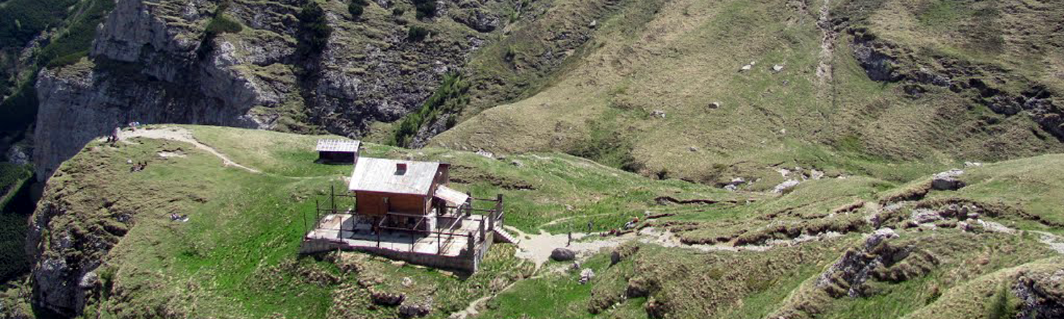
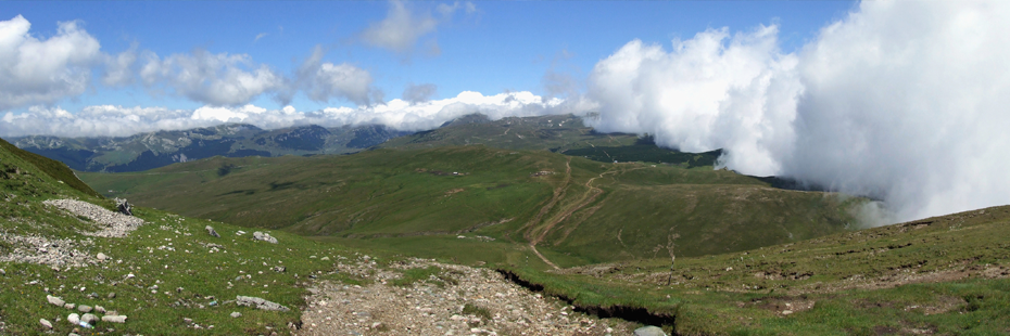
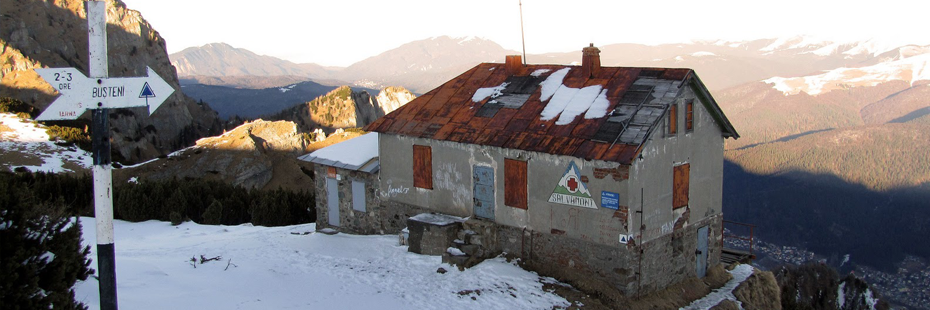
From Jepi Hamlet (1960 M) the trail goes V-NV, descending smoothly, it reaches a grassy plain where it meets the roads which comes from Piatra Arsa (on the left, 15 min time frame). From here, the trail goes right (marked in yellow line) under Vf. Ciocarlia(2056 m), goes past Urlatoarea Mare valley, then it climbs north onto the Jepi Mici plateau. In 20 min walk onto the plateau we reach a large ridge, at a crossroads (2120 m). There we can admire Jepilor Valley and beneath the valley we can see the Caraiman and the Cross. Junction towards Babele. We take the left trail and we reach the Babele-Jepi plateau, which divides Izvorul Dorului Valley and Jepilor Valley. The roads heads North, crosses the plateau and curves left facing West. In 10 min walk from the junction we reach a large threshold which we climb and then we reach another threshold, where we come across the path from Caraiman. In here, we climb for the last time towards the top to Babele Cabin (2200 m). Our trail towards Caraiman (marked blue spot) climbs slightly towards V. Jepilor. In 10-15 min walk, the trail crosses the valley and after a short climb on the opposite shore it reaches Caraiman cabin (2025 m).
Source www.muntii-bucegi.ro
Time: 3 – 3½ hours
Route sign:
From the Busteni railway station (883 m), following Libertatii Avenue on the left till Industriei street (10 min. from the station). From here we turn right into this street where we can admire the steep peak of Caraiman. In 20-25 min we get next to the Jepilor valley (the left, at the crossroads). Our path goes on further towards the stone quarry, which we reach in 10-15 min. From this spot we take the path to the left, which is a steep climb and then we move on to the right shore of Jepilor Valley (to our left). Moving forward we can see on our left the waterfalls of the Valceul Inspumat river.
The next perimeter of the path is carved in stone but secure through means of cables, this path goes up to the north slope of the Jepii Mici. In one hour of climbing we reach the Jepii peak. The path follows the Jepi and facing the Caraiman peak, winds up into a grassy slope. On the left we can see “Creasta cu Zimbri”, on the top of which there is a natural reservation of zimbri, the Romanian buffaloes and a reservation of cembra pine trees. Moving up again, the road crosses again the valley going on the Jepii Mici slope and then after it goes through some cliffs, reaches again the Caraiman peak. The path crosses some lush pastures and then goes down to a stone stair protected by cables. Way ahead you can see the Caraiman waterfall or “Vinturisul Caraimanului”, which is very impressive especially in spring and at the beginning of summer when the water from the melting snow floods it. On the left, over the valley, the Jepii Mici is covered in lush vegetation intertwined with stone walls here and there. In contrast with this rocky peak, on the other side on the right and above us, we can see the Caraiman clear and grassy slopes. A little further ahead the path crosses “Valceul Branei Portitei, after which it goes up again and reaches the Caraiman waterfalls, on the point in which on the right, it lies the Branei Portita pasture. Going on, the V.Jepilor path leads to the Valcelul Zapezilor (which is covered in snow most part of the year)…from which there is a stony part which climbs onto some stones, from where it leads onto a steep slope, moves into Valceul Zapezilor, and after a short climb you reach Caraiman Cabin (2025 m).
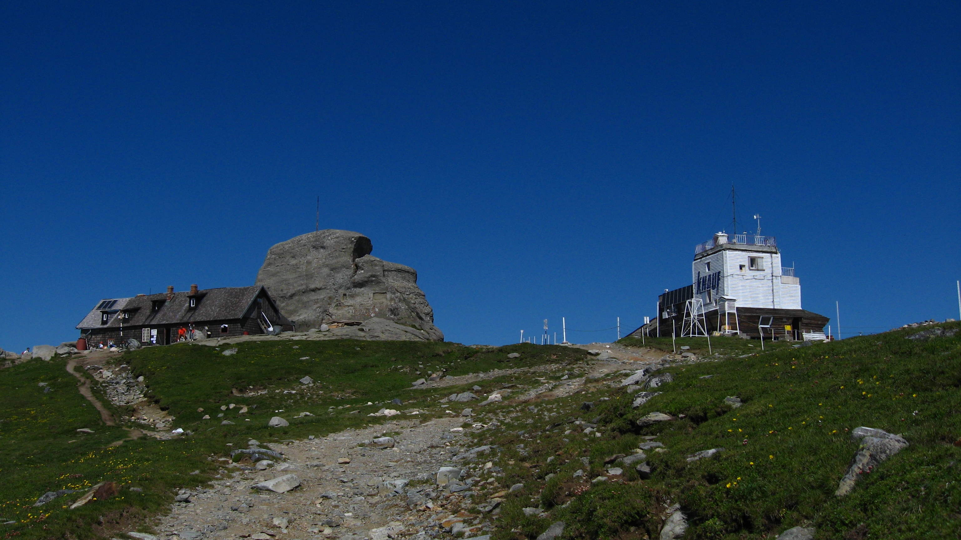
From Caraiman cabin (2025m) we climb west on the left shore (on the left as we go up) of the Jepi valley. We cross the pastures on the foot of the southern slope of the Caraiman and then we go up on the side of the valley and we go by the path which climbs up along Brana mare of the Caraiman peak, towards the Cross. After a short horizontal portion, the path gets near to the upper part of the V. Jepilor, at the crossing with Varoaga Babelor which comes from the west, from under the Babe peak. From here we go left, we cross the river and we go on climbing, parallel to the ravine, on its right shore (on our left). On the way to Babele-Jepi plateau we can see, on the left, the way to Piatra Arsa. After no more than 5 min. climbing we reach the top, the Babele cabin (2200 m).
Source www.muntii-bucegi.ro
From the Babele cabin (2200 m) we go down to the west, we cross some ravines and after 10-15 min we find ourselves above a rocky plateau, from which the path winds to the right, through a small passage and leads to the Piciorul Babelor, along which there is a area with boulders which leads into a field. The path crosses towards V. Cocorei (on the left), goes down along the Piciorul Babelor, where it meets, coming from the right, the road from Omu peak through the Obarsia Ialomitei, and after it crosses a southern reclined plateau, it reaches V. Cocorei and heads towards Petera cabin (1610 m).
Source www.muntii-bucegi.ro
From the Pestera cabin clearing (1610) the path starts in the north, crosses V. Cocorei, and passing through the pastures of a large reclined plateau reaches (10-15 min.) the crossroads. Moving on, the road goes towards Omu peak through V. Obarsiei (marked in a blue line). Our path climbs steeply on the right and in 15-20 min leads onto the Piciorul Babelor, where it keeps on climbing towards the ridge between the V. Cocorei and V. Sugarilor. The path crosses a rocky area, winds through a small passage, and then crosses the pastures under the Babele ridge and reaches the peak and the Babele Cabin (2200).
Source www.muntii-bucegi.ro
Starting from Babele Cabin (2200), the path goes west, down on the Babele ridge-Jepi, overcomes the way to Piatra Arsa (on the right) and goes on going down on the Babele Ravine, till it reaches Jepilor Valley. Parallel to this we climb a short area, at the foot of which we reach the path towards the Cross on the Caraiman through Brana Mare and there we get to Caraiman Cabin (2025).
Source www.muntii-bucegi.ro
Time: 2½h – 3h
route sign:
From Caraiman cabin (2025 m) the trail goes fast along the Valcelul Zapezilor (confluent on the left to V. Jepilor), it crosses the grassy slopes on the southern side of the Caraiman mountain, and then it meets again the Valcelul Zapezilor. Going through the left side, the trail reaches a break, goes on a small plateau and then takes right, meeting again the Valceul Zapezilor. From the impressive Caraiman waterfall (on the right), especially in spring, the grassy plain of Brana Portita emerges. Going down, the trail crosses the rocky side of Valceul Branei, then it goes along a steep area, first through a curve into the rocks, then on a stone stair and, eventually, in V. Jepilor. We cross the valley from the Craiman into the Jepii Mici and going down on a rocky area, then under the cliffs, we go again by the Caraiman, and after a long way down, we reach again the northern slope of the Jepii Mici. After we cross a stony path, we overcome the water fall of the Valceul Inspumat on the left, we go down again into an old stone quarry, and we end into the motor way. This leads into Busteni, through Industriei Street, into Libertatii avenue (the interstate). From here we go left on the avenue towards Busteni railway station. (10 min).
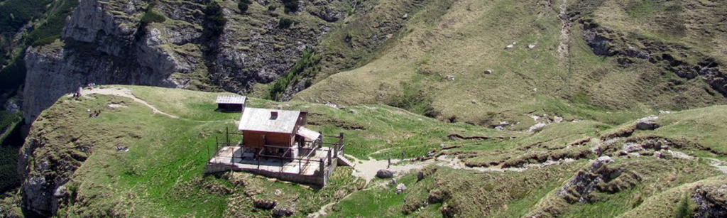
From the Caraiman cabin (2025 m) the trail goes south, crosses the V. Jepilor and goes steeply the slope on the right side of the valley. In 5-10 min. it reaches a plateau, from which it climbs into the border of the Jepii Mici plateau, in a ravine, where it meets the trail from Babele (on the right). From the ravine we go down south along the Jepii Mici plateau. We cross it in 15-20 min. and we reach V. Urlatoarea Mare (on the left) and we go on under the Ciocarlia Peak (2056 m), and after a plateau we reach a crossroads. One of the trails leads to Piatra Arsa cabin. We follow the trail on the right, we cross a bushy area and after 10 min. walk we reach Piatra Arsa cabin (1950 m). Our route (marked red triangle) winds left on the trail, first going down then going up, through a corridor and in 10 min we reach Jepi cabin, at the border of the plateau (1960 m).
Source www.muntii-bucegi.ro
Time: 40-50 min. up to the Cross; 2.1/2h till Omu peak
route sign:
From the Caraiman cabin (2025 m) we head NV in a steep climb on the trail to Brana Mare of Caraiman, a grassy path which winds under the southern peak of the mountain. We turn right along the path, we cross the rocky Sistoaca Dracilor, then we go up the steep way under the Omusor peak and soon we get to the Big Plateau of the Caraiman, on the border of which there lies the Cross. From the Cross we move on to the west in a steep climb and we reach the plateau on the Caraiman top. From here we go down the Caraiman slope and soon we reach the plateau of the Valea Alba, then we head NV, climbing mildly through beautiful pastures. On the left we overcome the ravines from the Jepi plateau, then the trail V-NV, crosses over a rocky area and meets in ½ h the route Babele-Omu peak.
From Busteni railway station (883 m) we take Libertatii Avenue (interstate) on the right, we turn left into Valea Alba Street and in 15 min. we reach the Caminul Alpin, from where we follow the Munticelul trail. We climb through the forest and in almost an hour we reach Masuratoarea Ursilor (1310 m), from where, on the left, there is the trail to Valea Alba.
Our trail heads a little on the right, it passes over the alpine Refuge “Costila” on the left (marked in a blue line) and after a short horizontal path, it goes down a slope, crosses V. Costilei, then V. Galbinelelor and in 25-30 min. from Masuratoarea Ursilor it reaches the Costila Clearing. On the left, above the forest, there is Santinela Vaii Cerbului, and below, the eastern slope of Costila, with Coltii Malinului, Galbinelelor and the great wall of Galbinelelor. Coming closer to the northern side of the clearing, we can see clearer on the left the Cerbu Valley. After a short descent on the other side of the peak we reach the crossroads “Poiana Vaii Cerbului” (1310).
Source www.muntii-bucegi.ro
From the crossroads “Poiana Vaii Cerbului” (1310 m) we go north on the trail through Poiana Vaii Cerbului, where we cross Malinului Valley (which is dry) and then Cerbului Valley (which has water now and then), passing by Costila Mountain to Morarului Mountain.Climbing through the forest, on the opposite shore, we cross Comorilor Valley and we go on climbing on the foot of the Morarului mountain. In 30 min. from the crossroads we reach V. Bujorilor. From here, after a short steep climb we reach Morarului Clearing. On the west side we can see Morarului Valley, and on the left, the northern slope of Morarului peak and the steep and rocky sides of Rapa Zapezii and Adanca valley and the rocky Morarului peak. The trail crosses the valley, passes by the Bucsoi Mountain, then through the forest, and after a short climb it reaches some clearings in Saua Capatanii Porcului, at the crossroads “Pichetul Rosu” (1445m).
Source www.muntii-bucegi.ro
From the crossroads “Pichetul Rosu” we go west the trail and in 20-30 min. we reach Bucsoiului clearing, from where we have o wonderful view of the Bucsoiului valley and the stony cliffs that border it. Then the trail crosses the the valley and after a large curve on the right it crosses Valceaua Bucsoaia and reaches a large clearing at the foot of Vaii Rele Ridge. From the clearing we climb a little and a ridge covered in grass and moss, “La Bataia Cocosilor de Munte”, from where we cross Valea Rea. Here the trail goes up and down, it crosses Valceul Indracit and then it climbs, reaching “La Prepeleac” in 1 ¼ h from the Pichetul Rosu. Leaving behind the old trail to Malaesti, we reach immediately the crossroads, from where there is on the left the path to OMU Peak, through Bucsoi (marked in a red line). Our tail goes on ahead on a path through the bushes. We soon climb down beneath the cliffs and cross a brook on a wooden bridge, then we go down and in 10 min. after the crossroads, we reach Valceul Prepeleacului, where we also meet the old trail. We go up on this trail and after some curves we reach Malaestilor plateau at the foot of a stone tower on the right, from where we can see the Malaesti Valley. Above the valley there is Padina Crucii, the Tiganestilor Ridge in the back and on the left the Peak of Scara Mountain. From the ridge we go down on the western slope of Bucsoi and we soon reach the Malaesti cabin (1720 m).
Source www.muntii-bucegi.ro
From Malaesti cabin (1720 m), the trail crosses the valley and heads east, climbing the western slope of Bucsoi. In 15 min. we reach a peak from where the trail winds through cliffy sides and after a short climb, it reaches Malaestilor plateau, at the foot of a stone tower. Beneath the plateau we can see Magura Cenusie peak and the Diham cabin, then Forbanului peak, Predeal resort, Piatra Mare peak and, on the right, Garbova ridge. Moving on , the trail goes down the opposite slope, on the Valceul Prepeleacului, leaves the valceu behind, and goes on the trail which climbs a little under stone walls. From this point it crosses a steep river bed, moves on onto the ridge and in 15 min from Malaestilor plateau it reaches “La Prepeleac” spot where it meets on the right the trail from Omu peak, marked in a red line, over the Bucsoi. From this spot the trail goes on the southern sode of the mountain, crosses the Valceul Indracit and goes on up and down; in 15-20 min from the Prepeleac it crosses Valea Rea and reaches the grassy mossy ridge, “La Bataia Cocosilor de Munte”. Going down on the other side, we enter a clearing on the foot of Vaii Rele Ridge, from where we can see the northern slope of Bucsoiul Mic. Soon we reach the Bucsoiului Clearing, where the trail crosses Valceaua Bucsoaia and then the Bucsoaia Valley and after a descent of 15 min, we reach the large clearing from under the Capatanii Porcului Plateau, at the crossroads “Pichetul Rosu”.
Source www.muntii-bucegi.ro
From “Pichetul Rosu” crossroads we go down mildly in the south through the clearing, on the border of which we go up the path through the forest. We walk on and in 20 min we enter Morarului Clearing, from where we can see clearly the rocky Morarului peak. We can discern from west to east the Acul de Sus pyramid, Degetul Prelungit, with its two peaks, Degetul rosu column, and at last, Acul Mare, in the shape of a huge trapeze. In the clearing we cross the dry river bed, and then after a short descent we get to V. Bujorilor. The trail keeps on climbing and in 20 min crosses the Comorilor Valley, and after it gets over a short ridge, it reaches Cerbului Valley. After a short climb we reach “Poiana Vaii Cerbului” crossroads.
Source www.muntii-bucegi.ro
Time: 1½h – 1¾h
route sign:
From “Poiana Vaii Cerbului” crossroads we take the trail south and we cross a short ridge, from which there is Costilei Clearing, that we climb, leaving behind Galma Mare peak (1428 m). From the southern side of the clearing the trail becomes milder, we enter Munticelului plain, we cross Galbinelelor Valley and further, Costilei Valley, after which we meet, coming from the right, the trail (marked in a blue line) from the mountain refugee Costila. In a few minutes, the trail reaches “La Masuratoarea Ursilor” clearing (1310 m) and on the right, there is the trail towards Valea Alba. From this spot the trail descends continuously along the plain and in 30 min it reaches Busteni, more precisely, next to Caminul Alpin. The station is at 15 min walk.
Time: 1¾h – 2h
route sign:
In order to take this route we have the following alternatives: a) From Busteni railway station (883 m), Libertatii avenue (the interstate) on the right till Nestor Urechia Avenue. From here we go left, we cross V. Cerbului and we follow Dihamului road. B) From Caminul Alpin Busteni we follow the path marked in yellow line, red line and blue triangle, which goes up through the forest and in 15 min it goes down in Cerbului road (towards Gura Diham). From the crossroad of the two paths we follow the road and in 30-40 minfrom Busteni and after we cross a small bridge over Hoagelor brook we reach the junction from Plaiul Fanului- Poiana Costilei (marked yellow line) and ahead, Gura Diham path (marked red line and blue triangle). Our trail (yellow line) takes left, through a large clearing, it goes up towards Galma Mare peak and reaches the NE corner of Costila clearing, where we a have a splendid view of the steep Costila peak. At the border of the clearing, the path takes right and goes up a cliff, from which we can see V. Cerbului and it descends on the other side of the peak and soon reaches the “Poiana Vaii Cerbului “ junction (1310 m).
Source www.muntii-bucegi.ro
Time: 3¾h – 4h
route sign:
From the the “Poiana Vaii Cerbului “ junction (1310 m) we follow the trail west along Vaii Cerbului Clearing(nearby, on the left Valceul Ascuns), we cross the river bed of Malinului Valley, we pass by Valea Verde (on the left), above which we can see Santinela Vaii Verzi, shaped like a pyramid, we move on through stone walls and we reach Cerbului Valley. The trail crosses the valley and follows the slope of the Morar mountain, climbing above the valley. In 10 min walk we can see Valea seaca a Costilei on the left. At the peak of the valley there can be seen Coltul Malinului, divided by Hornul Central. We pass by the frontal wall of Coltul Tapului and in 10 min we cross again Cerbului Valley and we overcome Costila Mountain towards Vaii Tapului clearing, at the end of Tapului valley. In the same clearing, Valea Urzicii gets down from SW, and ends into some boulders. Far ahead towards west, we can see the eastern slope of Priponului Peak and in the back The grassy slopes of Coltii Obarsiei Mountain. Above the ridge of Poiana Vaii Tapului, there is a hilly part that we climb through boulders covered in grassy subalpine vegetation. After 15 min walk from V. Tapului, we cross “La Numaratoarea Oilor”, where the path winds through 2 stone walls. Then we reach a large ridge bordered by a nettle clearing. We can see ahead the upper caldera of Cerbului valley, and on the right, the southern slope of Morarului, crossed by rocky and grassy plains. Moving on, we leave behind “Piatra Parlita”, an old shelter under a boulder, smoked by the fires of the shepherds who slept under it. Up ahead we can see Priponului Valley and Priponului Peak, and on the left, the borders of Caprelor Valley, in the shape of a vertical chimney above the clearing. At the upper end of the clearing it raises the peak of “Priponul Vaii Cerbului”, which divides the valley. The trail winds towards the entrance to Priponului Valley, goes on the slope of “Priponului Vaii Cerbului”, it ascends fast and winding through boulders it enters a stone passage. Coming out above the passage, the slope becomes milder and in 15-20 min from “Piatra Parlita” we reach a stone threshold which leads towards a plateau and a path which goes to V. Priponului. From here we follow the path under the ridge, we pass by Morarului side, from where we can see on the right Brana Mare a Morarului. Leaving behind the subalpine vegetation, we enter the alpine area. In 20-30 min time since crossing the valley we go over Costila again. The trail becomes steep and rocky and it curves towards another threshold, then it crosses the valley, goes up Morarului and soon, it gets on the border of the upper caldera of Cerbului Valley. From this spot we can see on the left, Coltii Obarsiei Mountain located in the rocky Ceardacul Obarsiei; onto the front, above the caldera we can see Vaii Cerbului peak and the calcite Vf. Gavanului peak (2479 m), and on the right, the Morarului long ridge. From the border of the caldera, the trail follows right the cliffs beneath the Vf. Bucura, covered in rhododendron forests and crossing manifold the Sistoaca Bucurei. The trail goes up the Morarului slope, and then it heads west, climbing along the slope of Culmea Bucurei., where it meets the path coming from the left, from Pestera and Babele, and from this spot it reaches Omu peak in e few minutes.
Source www.muntii-bucegi.ro
From Omu cabin (2507 m) we go SE in the upper caldera of the Cerbului Valley. Following the trail in the valley, we climb the slope of Costila. After a few curves the path comes out of the valley, goes up on a slippery rocky side, climbs again Moraru peak, and at the foot of another rocky area it goes back on the northern slope of Costila in the junction point with V. Caldarilor, where, on the E-NE, there is Brana Mare a Morarului. The path goes on the right side of the valley, passes by the path to V. Priponului and it reaches above Priponului Vaii Cerbului. After a curve on the right, the path enters a rocky chimney, then follows down the steep road next to V. Priponului (on the right) and enters “La Piatra Parlita” clearing. On the right, V. Caprelor emerges above the clearing like a tower. Going down, we pass by “Piata Parlita”, and down the trail, through “La Numaratoarea Oilor”, where the path winds through 2 stone walls, then we reach Poiana Vaii Tapului, and on the right V. Urzicii divides Costila slope into an area with boulders. A little lower we cross Cerbului Valley in the junction spot with Tapului Valley, from where we climb the southern side of Morarului, and then the path goes on climbing. On the right above the valley, there is the straight side of Tapului peak, and beneath, Valea Seaca a Costilei and Coltul Malinului. Leaving on the right the pyramid of the Santinela Vaii Verzi, we go down 15 min from Poiana Vaii Tapului into Valea Cerbului, we cross this valley and the steep Malinului Valley (at a short distance below, Valceul Ascuns), and after a short climb we reach “Poiana Vaii Cerbului” junction.
Source www.muntii-bucegi.ro
From the junction we follow the trail east and in a short while, we climb on the NE corner Of Costila clearing. From the border of the clearing, the trail takes left, it goes round Galma Mare Peak on the north and on the east, then it descends Plaiul Fanului and in ½ h from Costilei clearing it reaches Vaii Cerbului road. Following the road on the right, it crosses Hoagelor Brook and goes on in a large plateau, and in 15 min it reaches the junction right to Caminul alpin Busteni. Towards Busteni Railway station, we take the road, and from the outskirts of Busteni we take Nestor Urechia Avenue, then Libertatii Avenue. From here we take the first turning on our right and we reach Busteni station in 7-8 min.
For reaching this trail we have the following alternatives:
a) from Busteni railway station (883 m) Libertatii Avenue (interstate) on the right, till Nestor Urechia Avenue. From this spot we turn left into this street, and from the city limits, the road towards Gura Diham.
b) From Caminul Alpin Busteni on the trail (marked in yellow line, red line and blue triangle), which climbs slowly, then it goes down, and in 15 min it reaches the road from Cerbului valley, towards Gura Diham.
From this junction we move on onto the road and in 30-40 min from Busteni we get to the crossroads of Plaiul Fanului- Poiana Costila, which we leave behind on the left (marked yellow line). Our trail follows the road and in prox. 30 min it reaches Gura Diham Cabin (987 m).
Source www.muntii-bucegi.ro
From Gura Diham cabin (987 m) the trail goes N-NV, going up and then through the forest and the clearings from the ridge between the Valea Cerbului(left) and Valea Seaca a Baiului (right). Before entering the forest, we can see the steep peak of Costila on the left, V Cerbului and the eastern rocky slope of Morarului, which is called “Manusa Morarului”. After 15 min climb, we reach a clearing at a crossroads. The trail from the right climbs to Diham Cabin, through Baiului plain. Our trail ascends left, along a peak and reaches, in 15 min walk from the crossroads, on the ridge between the Valea Seaca a Baiului (right) and V. Morarului (left). From this spot, the trail goes along the western slope of piciorul Dihamului, climbing through a small clearing, from whose side we can admire Coltii Morarului, and then the trail crosses some springs and reaches at the foot of the large pastures of Diham. From here it takes left, it crosses Valceul Poienii Izvoarelor and it reaches immediately to Poiana Izvoarelor Cabin (1455 m).
Source www.muntii-bucegi.ro
From Poiana Izvoarelor Cabin (1455 m), the trail goes west and in 5 min walk it reaches a small clearing on the ridge between V. Sipotului (on the west side) and Valceul Poienii Izvoarelor (Valceul Porcului). From this spot we can admire the beautiful view of Bucsoi, Creasta and Coltii Morarului and beneath, the steep Costila, Caraiman and the Jepi. The trail crosses the glades from the southern side of Capatana Porcului Peak, and then it reaches Saua Capatanii Porcului, at the “Pichetul Rosu” junction.
Source www.muntii-bucegi.ro
From “Pichetul Rosu” crossroads we follow the path east. The trail goes by the foot of south slope of Capatana Porcului peak, then it reaches a clearing which separates V. Sipotului (on the west) from its affluent, Valceul Poienii Izvoarelor (towards east) and in 5 min it leads to Izvoarelor clearing (1445 m), at the cabin bearing the same name. From this trail visitors can admire Creasta Bucsoiului, Coltii Morarului and the steep northern slope of Costila Peak.
Source www.muntii-bucegi.ro
From the Poiana Izvoarelor cabin (1445 m), the trail goes east, crosses Valceul Poienii Izvoarelor (Valceul Porcului), gets down on the western side of Piciorul Diham, and in 15 min walk, it reaches a small clearing where the view of Coltii Morarului is astonishing. From this spot, the trail descends on the peak between the V. Morarului (in the west) and V. Seaca a Baiului, then it goes left, then after a large curve, it meets the trail which comes from the left (marked in a blue line), from the Diham Cabin. From this point we can descend and in 10 min we reach Gura Diham Cabin.
Source www.muntii-bucegi.ro
From Gura Diham cabin (987 m) we take the trail along the Cerbului Valley. In 20-25 min walk we reach the “Plaiul Fanului” crossroads where we meet, coming from the right the trail (marked in a yellow line) from Costilei Clearing, through Galma Mare. From here, the trail crosses Hoagelor brook, then goes on through a plateau and in aprox. 15 min, next to a left turn in the road, it passes by the path to Caminul Alpun Busteni (aprox. 25 min from the road, marked in yellow line, red line and blue triangle). Towards Busteni railway station we take the road and then Nestor Urechia Avenue which leads into Libertatii Avenue. From here we take right on the avenue towards Busteni railway station (10 min walk).
Source www.muntii-bucegi.ro